Hawaii Volcanoes National Park
I find that I appreciate a place more when I know how it got there. The stories of its origin, its geology, add to the depth of what I see before me. We learned some interesting geological facts from a Ranger talk and a sign posted at the Hohei Sea Arch trailhead. Volcanoes National Park consists of Mauna Loa and Kilauea Volcanoes. I've included the other 3 volcanoes here for the sake of completeness.
1. Kilauea
Kilauea is the volcano currently (as of 2017) actively erupting and the most active volcano on the Big Island. The only volcano that is actively releasing lava right now in Kilauea at two different hotspots, near its summit at Halema'uma'u Crater and at its East Rift zone at Pu'u O'o . The eruption at Halema'uma'u Crater has formed the biggest lava lake in the world, according to our Ranger. Halema'uma'u has been erupting since 2008. We visited in 2003, and were allowed to hike down into the Halema'uma'u Crater. It is now closed due to high levels of toxic gases. Views of the erupting crater can be had from the Jaggar Museum lookout. Daytime viewing will yield only a smoke stack. Come back at night, when you'll be treated by either a glow in the smoke stack (for low lava lake levels) or magma flaring into the air (for high lava lake levels). I overheard a Ranger explaining that the lava lake undergoes cycles of high and low lava levels every 3 days. So we made sure to come back on the third day. The first day's viewings yielded just a glowing smoke stack (which was pretty neat in itself), but on the third day, we were treated to magma flaring stimultaneously at two different spots. (My pictures just don't capture the flares, unfortunately.) Mother nature's idea of fireworks, and my idea of a perfect romantic date. The only thing that would have made it more perfect, is some warm milktea. And possibly more patient kids. The magic of flaring lava was lost on the boys after the first 15 minutes. I, personally, could have stood there all night, enjoying the light show. Oh ya, dress warmly. It got cold and rainy up by Jaggar Museum. Please check with Volcanoes National Parks website or the Visitor Center prior to your visit, as volcanoes are very dynamic and many changes have occurred since our visit in 2017.
**** UPDATE: As of January 2020, Kilauea has stopped erupting after erupting continuously for 30 years. In May to August 2018, Kilauea had a major eruption that quieted the eruption activity of all its vents. As change is inevitable with volcanoes, please check the Visitor Center or website for updated information. ****
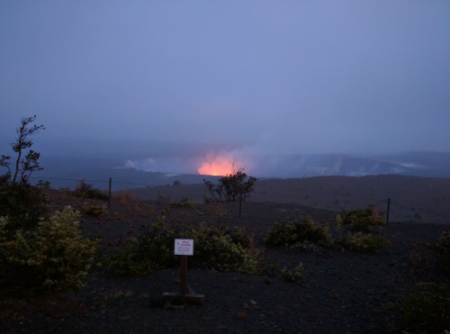 Daytime Lava lake at Halema'uma'u Crater from Jaggar Museum at LOW lava levels,Hawaii Volcanoes NP, Big Island, HI
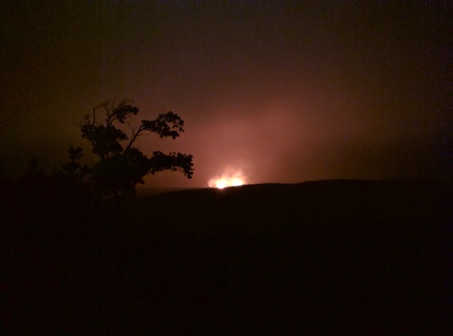 Halema'uma'u Crater lava lake flares at HIGH lava levels, Hawaii Volcanoes NP, Big Island, HI
Jaggar Museum is definitely worth a look. It has a display of the many forms lava takes. The one that caught my eye is one that looked like fine dirty blond hair, formed mid-air as lava is thrown out into the air from a forceful eruption. Ranger talks are also offered here. We attended one Ranger Talk on Geology, and I highly recommend it. Armed with the information I gained from the talk, I appreciate the Hawaiian Islands a lot more now. Rangers are also great resources for hikes in the area; more specifically updates on trails that might be closed due to unsafe conditions. Volcanoes and lava flows are incredibly dynamic, and conditions can change drastically quickly.
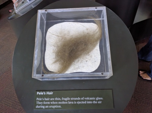 One of many forms lava can take, Pele's hair, Hawaii Volcanoes NP, Big Island, HI
| Features: | View of hot glowing lava in the center of a crater, learn about volcanoes and lava at the Jaggar Museum |
|---|---|
| Jaggar Museum Hours: | Daily 10am to 8pm, Observation Deck open 24 hours |
| Fee: | $25 per private vehicle for 7 days, Intra-agency Annual Pass accepted |
| Don't Forget: | Jacket, Flashlight |
| Website: | Volcanoes National Park |
The Pu’u O’o eruption had been erupting continuously since 1983, the longest erupting volcano in historical time. Kilauea produces 250,000 to 650,000 cubic yards/day of lava. That is the equivalent of repaving a 20 mile two-lane road every day. Pu’u 'O’o is the hotspot from which the 33 year old eruption originates. When we last visited the Pu'u'O'o eruption in 2003, we were made very aware of mother nature's power as we looked on to the incandescent liquid rock flowing about 20 feet away. As we closed in on the lava flow of over 2000F (1100C), the air temperature increased substantially. We started with fleece jackets, and I was down to a tank top and covered in sweat when we got close to the lava flow. This lava flows 6 miles (10 km) from its vent in the mountains to the ocean via lava tubes. As it makes its way to the ocean, the lava crossed the Chain of Craters Road, forcing closure of that road. Lava flow burned down a Visitor Center along that same road. The strong surf also has recently caused the unstable lava shelf formed to fall into the ocean. So, it's a good idea to heed warning signs set up by National Park Service. There is a hike from the end of Chain of Craters Road now (June 2017) to view the lava flow. The trailhead is near the Hohei Sea Arch. The hike is said to be a 10 mile hike round trip, with no water or shade available along the way. We started on that hike, went about 2 miles one way on a wide gravel road, enjoyed the many types of lava along the way, but decided to turn back since we were running low on water, and had no food left in our packs. I hear at the end of the hike, there is a section where you'll have to take to the unforgiving lava rock to view the hot lava, and we weren't sure that we were sufficiently equipped on that day.
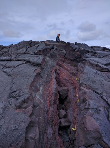 Sitting on top of a Lava Dome along the trail to Pu'u O'o Eruption, Big Island, HI
The Hohei Sea Arch is a short walk from the street parking at the end of the Chain of Craters Road. It is an interesting feature the product of erosion on lava rocks, visible from the top of the lava cliff.
There is a third option for lava viewing. There is a hike to the Lava viewing area from the Kalapana side. Since the Pu'u O'o eruption reached the Chain of Crater Road, the connection to Kalapana has been closed off. To get to the Kalapana side, you'll have to exit the park, go around to the end of Highway 130. Since the trail opens at 3pm (trail hours: 3pm-9pm), we took this opportunity to explore the tree-canopied Red Road in Puna (Kalapana-Kapoho Rod) beforehand - more on this here. The hike to the Lava Viewing area from the Kalapana side is a 8-9 mile hike return with no shade. It would have been a hot hike if it weren't for an ocean breeze (a sign indicated temperatures of 95F). The hike itself wasn't terribly beautiful, a wide dusty gravel road shared with bicycles and pickup truck shuttles. The last 15 minutes of hike was on rough uneven rocks. Gloves are advised by NPS, which is a good idea, as a I had small tumble when my ankle rolled. Those rocks are sharp and cuts a deep jagged wound that takes a long time to heal. *******Volcanoes and lava flows are incredibly dynamic. Conditions can change drastically quickly. This area may not be available due to the eruption of 2018. Please check with National Parks Rangers during your visit.*********
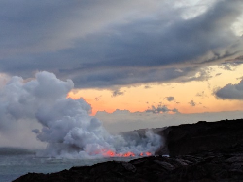 Lava Falls falling directly into the Pacific Ocean from Kalapana Side, Big Island, HI
We started our hike at 3pm and arrived at the viewing area at about 5pm. During daylight hours, the lava appeared as a smoke stack where the cliffs met the ocean, and as a line of smoke in the mountains. We decided it would be wise to stay until sunset. The two hours we stayed went by quickly as we stared at the falling lava into the ocean, while trying to keep the boys' energy level constructive. From time to time, I would spot a stream or two or three of orange glow flowing into the ocean. Every time, I had to remind myself that this is a real life lava falls, falling into the ocean. I wonder how many lava falls there are in the world?
At 7pm when the sun set, the orange glowing lava falling into the ocean looked like a wide waterfall of lava crashing into the ocean. It was a wide falls, but standing a half mile away afforded only so much detail for my camera, though my eyes seem to pick up the details a little better. I was glad we were able to see both the daylight and sunset versions of these lava falls, as new land is built on Hawaii’s youngest and biggest island. It took 2 hours for us to hike in to the viewing area, as my youngest son is unmotivated by wide flat trails. Along the way, we noticed small homes on the barren lava beds. It does have an ocean view. It took us 1.5 hours going out, since we were motivated to arrive back into town before dinner closed for the night. On our way out, keep an eye on the mountain. Where the lava flow appeared as a line of smoke during the day; at night, it appears as flickering spots of orange glow as the molten lava breaks the surface in different spots.
It's a good idea to check with Visitor Center (Kilauea Visitor Center in the Park) for updates on lava flows before going. Lava flows are very dynamic and changes occur frequently that may affect safety. Bike rentals are available at parking area of the Kalapana side. There were also vendors advertising one-way shuttles. Bring flashlights, ideally one per person, to find your way out of the sharp rocks, and to allow shuttling pick-up trucks and bicycles to see you on the way back in the darkness of the night.
| Features: | View of a real lava falls falling into the ocean. Night time viewing better than daytime viewing. |
|---|---|
| Our Hike: | 8-9 mile rt, bike (rentals available) or hike, the last 10-15 minute walk to the viewing area is on sharp, jagged a'a rock |
| Trail Hours: | 3pm-9pm, check with Visitor Center for updates before going |
| Directions: | Exit Volcanoes National Park, drive around to the end of Hwy 130. We drove the Red Road to Puna and Lava Trees State Park along the way. |
| Don't Forget: | Water, sunscreen, hat, flashlights, gloves (to protect hands if you fall on sharp rocks), snack if you go early and have to wait |
| Website: | Volcanoes National Park |
The first hike we did in Volcanoes NP was the Kilauea Iki Trail and the Thurston Lava Tube. Our hike was a pleasant 4.5 miles rt hike including the lava tube. The lava tube portion was short, maybe 1/2 mile total, and was a short spur trail just off the Kilauea Iki Trail. The lights in the lava tube were out due to some flooding when we visited, so our flashlights came in handy. There is parking close to the lava tube but we opted for the emptier parking lot at the beginning of the Kilauea Iki Trail less than a mile away. The trail is uneven and wet, so shoes with good traction will be useful. The walk in started under giant ferns, then into a lava tube that used to hold hot flowing lava. As the external structure of the lava tube cooled, the inner flowing lava continued to flow until it all emptied, leaving a tunnel-like structure, some large enough to fit large trucks. This particular one fit full-grown adults with no ducking, most of the way. So while walking in the Thurston Lava Tube, know that you are walking on rock where hot molten magma flowed 500 years ago.
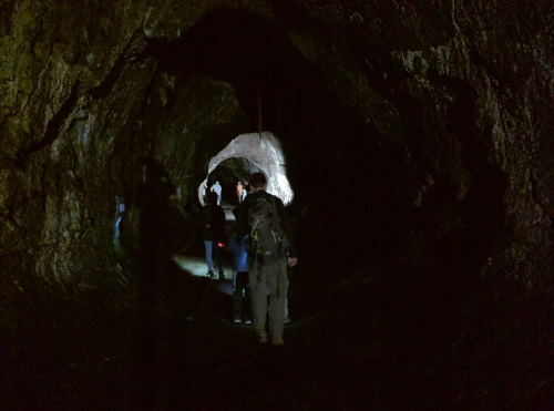 Walking through the dark and damp Thurston Lava Tube, Big Island, HI
Our hike in the Kilauea Iki Crater consisted of walking down the humid (giant) fern-lined crater walls. Near the bottom, there was a barren field of solidified lava stretching in front of our eyes. As we walked across the lava field, we saw the different types of lava, including pahoehoe (rope-like lava) and a’a (rough, sharp rock lava). There was a buckle in the lava caused by what looked like a fissure that crossed our trail.
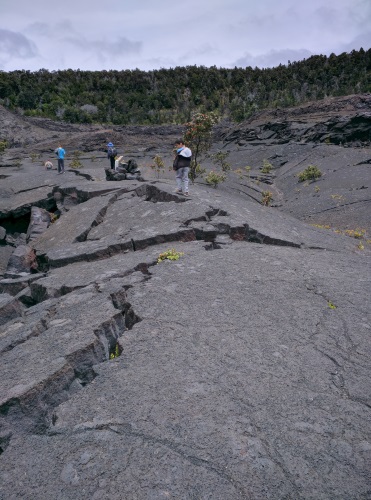 Walking along a fissure in the crater floor of Kilauea Iki Big Island, HI
As we made our way across, we were rained on near the middle of the crater. As we got to the other end of the crater, the rain stopped and it got hot again as we climbed up the other crater wall, covered by the same vegetation as the wall we walked down. We ate our lunch near the bottom of the crater wall and wondered if it will be the site of the next eruption.
It is a good idea to wear closed-toe shoes with good traction, a hat and even a rain jacket might be useful. We got rained on briefly at the bottom of the crater. Water and sunscreen will prove their worth as well. Flashlights are useful for the lava tube.
| Features: | Walk down a crater wall lined with giant ferns, onto the center of a solidified lava lake, enjoy a tour of a lava tube along the way |
|---|---|
| Our Hike: | 4.5 miles rt, uneven terrain, some shade, some unshaded |
| Trail Hours: | 3pm-9pm, check with Visitor Center for updates before going |
| Don't Forget: | Flashlight, sunscreen, water, hat, rain jacket |
| Website: | Volcanoes National Park |
2. Mauna Loa
Mauna Loa is the biggest volcano on Earth covering 85% of Big Island. It is the second most active volcano on Big Island. Its name Mauna Loa, means 'Long Mountain'. It appears as a hill in the distance, even though it stands at 13,700 feet above sea level, just 100 feet below Mauna Kea. It's base sits a whopping 55,700 ft below its summit, deep below the sea floor, the sea floor depressing 26,200 feet under the weight of the mountain (per USGS). It's slopes are gradual, and is the largest active volcano in the world. Its last eruption was in 1984, when its flows threatened the city of Hilo, stopping just short of 5 miles from the populated city. It has erupted 33 times since the 1840s.
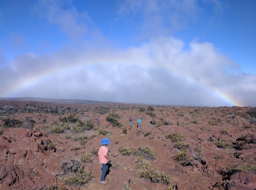 Looking for the elusive pot of gold on the biggest active volcano in the world, Mauna Loa, Big Island, HI
We did an 8 mile hike (rt) up the slopes of Mauna Loa, just to walk on the biggest active volcano on Earth. The hike started in lush vegetation, then slowly more scattered bushes, making visible the many lava features, in particular large diametered pahoehoe (rope-like lava). At around 8100 elevation, vegetation was scarce. At 9000 feet, the landscape turns to red rocks, but we stopped at 8100 feet. Along the road to the trailhead at 6600 feet, there was a clear view of Halema'uma'u erupting Crater atop Kilauea's summit. The road to the trailhead was one lane for a few miles before the trailhead.
At the base of Mauna Loa was a Tree Mold area. Lava flowed over trees, which eventually combusted and left empty skeletons of those trees 10-20 feet deep. The depth of the lava is the depth of the tree molds. Hold on to kids here. Most have rails around the holes, but young kids can easily fall through.
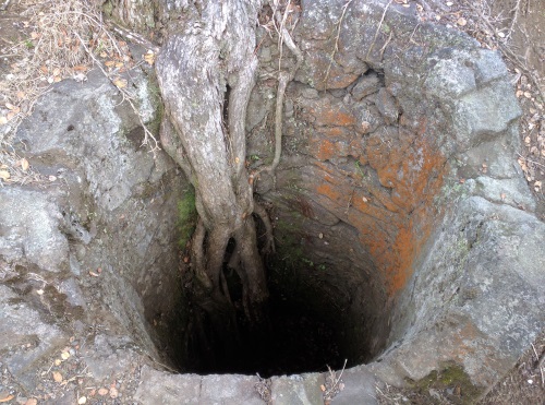 Tree molds near the above sea-level base of Mauna Loa, Big Island, HI
3. Mauna Kea
Mauna Kea sits at 33,500 feet from its base under the sea, which puts it taller than Mount Everest at 29,000 feet, when measured from its base. Unfortunately, only 13,800 feet of Mauna Kea is above sea level. It is considered an active volcano, its last eruption being around 4500 years ago (active: any volcano that has erupted in the last 10,000 years). Mauna Kea is the only Hawaiian volcano to have been covered by glaciers in the last Ice Age.
We drove to the Visitor Center in Mauna Kea one night to watch the sunset and moonrise from a hill nearby. We stood above the cloudline. The clouds looked like water rolling into the shores of a beach at sunset.
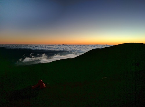 Sunset at Mauna Kea as the clouds roll in, Big Island, HI
After watching the sunset, we headed back to the Visitor Center. There was a free Stargazing program that started at 8:15pm and lasted about an hour. There were also telescopes set up in the front of the Visitor Center aimed at different celestial bodies. This program is held on Tuesdays, Wednesdays, Fridays and Saturdays. The talk was very informative, even if it was on a full moon night. We saw a satelite come into view a few times, spotted a shooting star as our tour guide pointed out several constellations, Saturn and Jupiter.
4. Hualalai
Hualalai is the volcano closest to Kona and Kona Airport. It has erupted 3 times in the last 1000 years, and 8 times in the last 1500 years. Its last eruption was in 1801, whose lava flow now underlies Kona and Kona Airport. It is expected to erupt approximately every 200 years.
5. Kohala
Kohala is the oldest volcano on Big Island. It is considered extinct. It's last eruption was 120,000 years ago. It's northern slopes are currently experiencing erosions, creating the deep valleys of Waipio, Polulo and all the valleys in between. The slopes here are beautifully lush, covered with Pandanus trees, mango trees, giant ferns, guava trees and many others that I didn't recognize. More on hikes to Waipio and Polulo Valleys here.
More Hawaii Travel Ideas More U.S.A. Travel Ideas More Worldwide Travel Ideas
