Point Reyes National Seashore
Alamere Falls
We started our hike at 9:30am on a quiet, rainy late November Saturday morning. The parking lot had five or six cars. We began at Palomarin Trailhead, then followed the Coast Trail, then onto the Alamere Falls turnoff. The Coast Trail gave us a view of the ocean below, then into a few groves of trees. We also walked by two lakes, Bass Lake and Pelican Lake. The latter, Pelican Lake is a lake with a peek-a-boo view of the ocean in the background. The trail was dotted with puddles, large and small, which required puddle jumping, sidestepping and occasionally carry-overs by daddy. I think that made it a little more exciting for the boys. We encountered at least 3 salamanders and an equal number of banana slugs. The boys spent a few minutes watching them get merrily on their way, albeit very slowly.
 Ocean Views along the Coast Trail, Point Reyes National Seashore, CA
The Alamere Falls turnoff was UNmarked by official signs. We found it about 0.1 to 0.2 miles after Pelican Lake, off the Coast Trail, before an official sign for the turnoff for Ocean Lake Loop. A small, unassuming, unmarked turnoff on the left, we would have missed it completely if it weren't for an arrow built by rocks. Someone had also built the word “DEATH” just below the arrow which deterred us just a little from going down that small lane. We followed the Coast Trail more than ½ mile beyond what was necessary, then turned around to the Death arrow to try our luck there. From the turnoff on Coast Trail (aka where Death arrow laid) to the Falls, called Alamere Falls Trail on my GPS, it was about a ½ mile walk. We did Not encounter much of the human waste issue along the trail as I had read in other reviews, possibly due to rain in the past two days.
 Rock Arrow to show us the path down towards Alamere Falls, Point Reyes National Seashore, CA
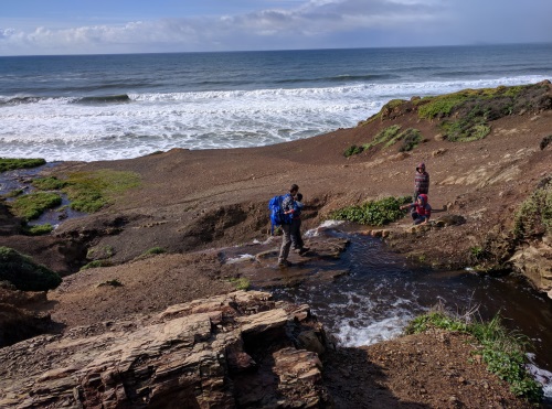
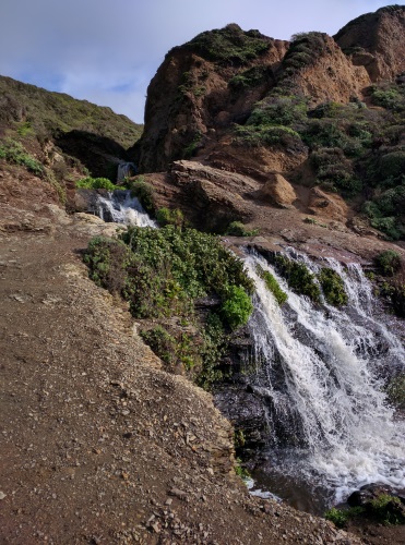
The narrow trail opens up to a much wider trail, eventually with a view of the ocean below. As we closed in on the falls, it became obvious that there was going to be some rock scrambling involved. We sent our best footed hiker to scope things out. My husband came back with a thumbs up for the rest of us to head down what I would describe as large dirt channels, with some rocks embedded in it. The climb down was not too bad for us, (nor was the climb back up). My kids got a helping hand from dad, and we all made our merry way down. The next challenge was a stream crossing, a crossing that occurred just above the second tier of the waterfall. There was a flat rock embedded near the middle of the stream, and with a little helping hand from dad, all kids and myself made it safely across. Unbelievably, we were the only ones at the waterfalls. Walking downstream a little along Alamere Creek, we could see the 3 tiers of the falls. Beside the stream is some dry land and some rocks, which we used as a seat to have lunch while enjoying the view of the waterfalls and the Pacific Ocean’s waves pounding below us. It was quite a unique view, having three tiers of waterfalls to our left, and the crashing waves of the ocean in front of us.
 Climbing down dirt channels towards Alamere Falls
 Stream crossing just above the second cascade of Alamere Falls
Looking beyond the cliff, we peeked on to the last tier of waterfall, the largest of the four. This tier of falls fell over a tall cliff, directly onto the ocean's beach. Looking from above, we noticed footsteps in the sand below at the foot of the cliff. My husband did some exploratory scouting, then came back with the go-ahead. This rock scramble was more difficult - the rocks were slippery and the shale rock broke apart easily. Amazingly, the boys took their turns patiently with daddy helping them along. Little by little, we made it to the bottom. We walked to the bottom of the last tier of falls for a quick picture, before being scared off by a particularly large wave that came ashore. We pulled ourselves back up to the cliff to find some company alongside the falls. More company soon followed.
 The top 3 cascades of Alamere Falls
 Descending the shale rock wall - about 30 feet - to reach the last tier of waterfall
After lunch, as it always seems to be the case, the energy from the meal goes directly to the boys' legs so it was time to call it a day. As we made our way back to the car around 2pm, we noticed more hikers coming in, even as the rain started beating down pretty hard. We felt lucky to have had the waterfalls to ourselves even for just a short while. Our entire hike, lunch and "wildlife" watching included, took just under 6 hours. We clocked in 10.1 miles on Strava, thanks to us overshooting our turnoff at Alamere Falls Trail.
 The last tier of Alamere Falls, the cascade that falls onto an ocean beach
| Features: | Walk under groves of different trees to a 4-tiered waterfalls that falls onto an ocean beach, pass 2 ocean-side lakes and enjoy ocean views along the way |
|---|---|
| Our Hike: | Just about 10 miles return, moderate due to some rock scrambling at the end to get down to the waterfalls, total elevation change 500-600 ft including climbing down to beach |
| Fee: | Free |
| Directions: | Palomarin trailhead is at the end of Mesa Road, a winding road off of Olema-Bolinas Road, off Hwy 1 near Woodville, CA |
| Amenities: | vault toilet at trailhead only, no facilities on trail |
More California Travel Ideas More U.S.A. Travel Ideas More Worldwide Travel Ideas
