Coyote Hills Regional Park
Not too far off from the freeway in Fremont, past Ardenwood Historic Farm, there lies a gem that is much hidden to passersby. A beautiful open space that is teeming with wildflowers in the spring overlooking the San Francisco Bay. The recent rains have worked their magic on the hills in this area, making them wonderfully green, dotting them with colorful wildflowers and filling marshlands with water.
 Wildflowers at Coyote Hills Regional Park, Fremont, California
We walked on Soaproot Trail which led us to a lookout on the water overlooking salt ponds in the San Francisco Bay. On the day of our hike the salt ponds were a bright yellow in color, which made the view all the more beautiful. I have read that the color of the ponds change according to which organisms grow in it, which is based on the level of salinity of the ponds. Apparently the color can range from bright green to a deep red, and everything in between. I imagine red would be quite a sight to see. From what I read, it sounds like there is a project underway to convert these salt ponds back to the original tidal wetlands it once was. This is good news, however it means these colorful hues will not be around for our viewing pleasure forever. To the south of our Soaproot Trail lookout, we had a view of Dumbarton Bridge. Though we saw several planes making their final approach to SFO, we didn’t hear them. It was amazingly quiet for the amount of car traffic from the bridges and plane traffic from above. Perhaps it was how the wind was blowing that day, but we were definitely thankful for the quiet.
 Big Sky Above Yellow Salt Ponds, just offshore from Coyote Hills Regional Park, Fremont, California
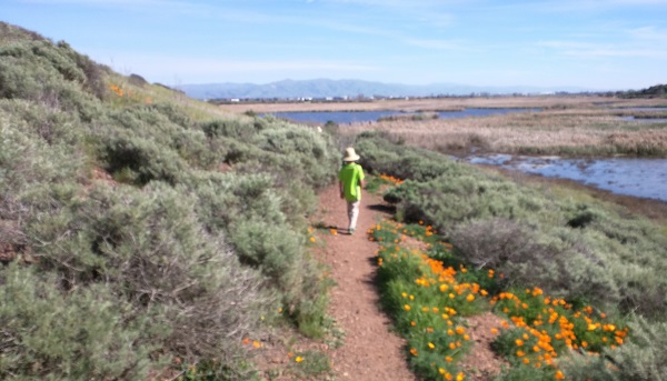
From Soaproot Trail, we walked up a hill where the Glider Trail started. The view from the hills was beautiful. We looked across the Bay with amazing views of the bright yellow salt ponds to the west; to the North, California poppies brighten the hills dotted with chaparral rocks. We made our way down our hill onto the Red Hill Trail to get up close to more California poppies and a view of the San Mateo Bridge to the north. From there we made our way down onto the Nike Trail and back into the marshes.
 Walking through the wildflowers towards the Marshes, Coyote Hills Regional Park, California
There is a paved trail – Bayview Trail – that runs along the water on what seemed like relatively flat ground. Intersecting the Bayview Trail is Alameda Creek Trail, a 12 mile trail that runs to the mouth of Niles Canyon to the east. We are definitely considering bringing our bikes in next time.
The Visitor Center has a boat display made of the reeds found in the marshes. It also has a diorama of an Ohlone Village. Adjacent to the Visitor Center is a Nectar Garden that features birds and butterflies.
There is a parking fee of $5 (as of February 2016) if you would like to park inside the park. We saw many people walking in from the additional parking area outside – a little over a 1 mile walk to the Visitor Center. Or you can take the Chochenyo Trail (a little over 1 mile to the Visitor Center) – look out for the trailhead immediately after the entry kiosk on your walk in. It will take you through tall cattails past a 2000 year old Ohlone Village Site. Unfortunately, the Village is not always open to the public. We were lucky enough to see a Naturalist leading a tour when we walked by and peeked in. Naturalist tours start at the Visitor Center and last about 2 hours – check/call the Visitor Center for information on this. The Chochenyo Trail took us on a boardwalk that allowed us to cross the marsh. There were fish and ducks swimming in the marsh waters. The kids entertained themselves with the marsh reeds growing along the trail. (Bug spray might be a good idea - I had a couple of mosquito bites walking through the marshes)
There were some picnic tables by the Visitor Center. We also saw poison oak along the way, so mind what you touch. On that day, we hiked over 6 miles. But certainly a shorter (or longer) one can be done. Pick up a copy of the trails map at the Visitor Center and map out the trails you want to take. Happy Exploring!
| Features: | View of Colorful Salt Ponds (yellow during rainy season, pinkish/red during dry season), Bay, Marshlands, Ancient Archaelogical Site of Ohlone Indians |
|---|---|
| Address: | 8000 Patterson Ranch Rd, Fremont, CA, GPS: 37.553919, -122.091770 |
| Hours: | Park Hours: 8am to 6pm or 8pm (depending on season
Visitor Center/Nectar Garden Open Hours: Wed-Sun 10am to 4pm |
| Telephone | (510) 544-3220 (for Naturalist tour information) |
| Fees: | Parking: $5, Dog Fee $2 (on leash only) |
| Website: | For most updated information, please visit website |
More California Travel Ideas More U.S.A. Travel Ideas More Worldwide Travel Ideas
